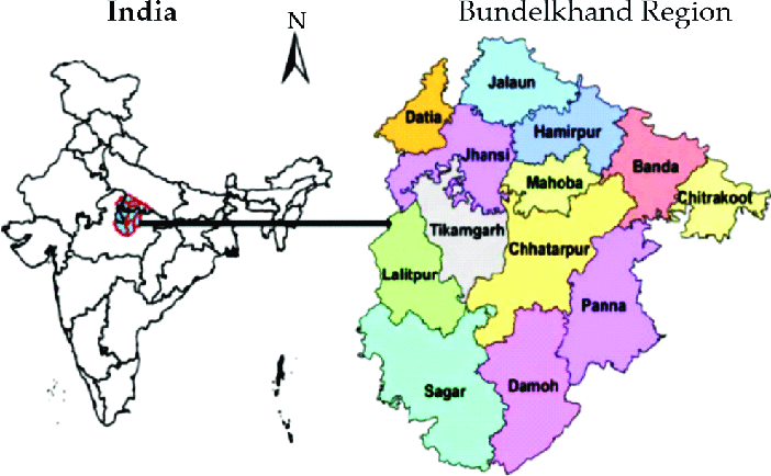
Bundelkhand is a geographical and cultural region, divided between the states of Uttar Pradesh and Madhya Pradesh. Jhansi is the largest city of Bundelkhand and Sagar is the second-largest city. the area of Bundelkhand is 59000 sq km, spread over 7 districts of Uttar Pradesh namely Chitrakoot, Banda, Jhansi, Jalaun, Hamirpur, Mahoba, and Lalitpur, and 6 districts Chhatarpur, Tikamgarh, Damoh, Sagar, Datia and Panna of Madhya Pradesh.
Districts of Uttar Pradesh
1. Chitrakoot
The place of the religious, cultural, and historical importance of the Bundelkhand region is situated on the border of Uttar Pradesh in the Chitrakoot region. Its headquarter is Chitrakoot Dham. It is mainly situated between Uttar Pradesh and Madhya Pradesh. It is known for many temples and pilgrimages of Hinduism. It attracts pilgrims throughout the year on Amavasya, Somvati Amavasya, Deepawali, Sharad Purnima, Makar Sankranti, Ram Navami, etc.
-
Geography
Chitrakoot means the hill of many medicines. This district belongs to the northern Vindhya range in Uttar Pradesh and Madhya Pradesh. It is included in the Chitrakoot district of Uttar Pradesh and the Satna district of Madhya Pradesh. This district in Uttar Pradesh was formed in 1998. Kamadgiri, Hanuman Dhara, Janki Kund, Lakshman Pahari, and Devangana are famous religious mountains mainly in the Chitrakoot range. The distance from here to Bamrauli airport in Allahabad is 106 kilometers. In the mythological period, Lord Rama, Goddess Sita, and her brother Lakshman had spent 11 years in Chitrakoot during their 14 years of exile. Due to this, there are many religious places. It is said that all the gods and goddesses have a permanent abode here.
-
Major Tourist Destination
The major religious and tourist places to visit in Chitrakoot are Ramghat, Kamadgiri, Bharat Milap, Janki Kund, Sati Anasuya Ashram, Gupt Godavari, Pampapur, Hanuman Dhara, Bharatkoop, Ram Saiya, Rajapur, Ganesh Bagh, Sitapur, Kamtanath, Dharkundi, etc.
2. Banda
Banda is a district in Uttar Pradesh state. It is divided into North, East, West, and South. It is situated to the south of the Yamuna River. The Ken river passes through the right of Banda. It is located 189 km southwest of Allahabad. Banda was a part of the Allahabad Division during the British period. The main Maratha ruler here was Shamsher Bahadur 1st. He was the son of Bajirao 1st and Mastani. He contributed to the third battle of Panipat. In which he was injured and died. After that, his successor Ali Bahadur took over the rule of Banda. He was followed by his son Shamsher Bahadur 2nd who fought the British in the Anglo Maratha War of 1803. The main dialects of Banda are Hindi and Urdu. Bundeli language is spoken regionally here.
-
Geography
Banda district is also called the hottest place in the country. The average temperature here reaches 48 degrees centigrade in summer. The minimum temperature of this district in winter is between 8 degrees centigrade to 20 degrees centigrade. The annual rainfall in this district varies from 15 mm to 800 mm and the average humidity is around 50 to 70%.
-
Major Tourist Destination
The major tourist places to visit in Banda are Bam Deveshwar Temple and Hills, Ken River, Bhuragarh Fort, Hanuman Ji of Gudha, Jain Temple, Jama Masjid, Kalinjar Fort, Angleswari Devi, Maheshwari Devi Temple, Nawab Tank, Sankat Mochan Temple, St George’s Church.
3. Jhansi

Jhansi is a historical city in Uttar Pradesh. It is situated on the banks of the Pahuj river in the south. It is also known as the Gateway of Bundelkhand. It is 420 km from New Delhi, 102 km south of Gwalior. Jhansi is very well connected to other major cities of the state by road and railway network. It is also being developed as a defense corridor by the Government of India. The North-South Corridor from Srinagar to Kanyakumari passes near Jhansi. Due to this, there has been a spurt in the development of infrastructure and real estate here. Jhansi was the third cleanest city in Uttar Pradesh in the Swachh Survekshan 2018 rankings. A greenfield airport development is being planned here. It has also been selected under the Smart City Scheme of India. In ancient times Jhansi was the kingdom of Chandel Rajput kings. It was also known as Balwant Nagar. In the 17th century, Rajveer Singh Deo, the king of Orchha, built the fort of Jhansi in 1613. In 1729 it came under the Maratha kingdom. Jhansi was the capital of the Maratha province in the 18th century and became part of the British princely state after 1857. After independence, Jhansi was included in the state of Uttar Pradesh.
-
Geography
The average height of Jhansi is 284 meters above sea level. Jhansi is a plateau region known for its rocky soil minerals. There is a natural slope to the north of the city. This is due to being situated on the southwest boundary of the vast plain of Uttar Pradesh. The land of Jhansi is more suitable for citrus fruits. Wheat, pulses, peas, and oilseeds are mainly cultivated here. Agriculture here is mainly dependent on monsoon rains. It is also a major center for the manufacture of brass utensils. Lime and granite stones are being mined here.
-
Major Tourist Destination
The major tourist places of Jhansi are Jhansi Fort, Jhansi Museum, St. Jude’s Shrine Church, Rani Laxmi Bai Park, Parichha Dam, Baruasagar, Jhansi Herbal Garden, Rani Mahal, Baruasagar Fort, Ganesh Temple, Maharaja Gangadhar Rao ki chhatri, etc.
4. Jalaun
Jalaun district was primarily a part of the Maratha Empire. It was captured by the British in 1803 and it remained a British protectorate till 1806. The Maharashtrian Pandits living here were known as Dakini Pandits, as their ancestors had been in the service of the Maratha Peshwa. The last ruler of this place, Govindrao 2nd, died in 1840 AD. After which the British took full control over it. In 1860, the Garhwali outpost at Kalpi, the residence of the former rulers of Jalaun state, was demolished and replaced by Baithganj. After independence, the authorities preferred Orai for the capital of this district as Jalaun was a backward place.
-
Geography
This district is a part of the Jhansi division. The area of the Jalaun district is 4565 square kilometers. This district is situated in the plains in the north of the hilly region. It is almost surrounded by the Yamuna river. which forms its northern boundary. Its tributary Betwa forms its southern boundary and Pahuj forms its western boundary. The tree cover in this district is very less and there is moderately fertile land for agriculture. The Gair river flows through the middle of the district through several small rivulets. This district is also prone to drought-like other areas of Bundelkhand.
-
Major Tourist Destination
There are many historical places in the district. Of which Rampura Fort, Jagammanpur Fort, Lanka Minar, Chaurasi Gumbad, Sharda Temple, Koch’s Ramlila, Shalaghat, Jageshwar Temple, Pachnada Dham, Veda Vyas Temple, Sun Temple are the main.
5. Hamirpur
Hamirpur district is a part of the Chitrakoot Dham division of Uttar Pradesh. Hamirpur is bounded by the districts of Jalaun, Kanpur, and Fatehpur in the north, Banda in the east, Mahoba in the south, and Jhansi and Jalaun districts in the west. Its area is 4121 square kilometers. In 2011, it was the third least populous district after Chitrakoot and Mahoba. Here, thick sand is found on the banks of the Betwa river. Which is exported to many parts of Uttar Pradesh.
-
Geography
Most of the Hamirpur district has a small forest cover. The northern boundary of the Hamirpur district is formed by the Yamuna River. The length of which the district is about 56 kilometers. The northwestern boundary is formed by the Betwa River. This river enters from the Jalaun district near a village named Beri in the Hamirpur district. Other rivers in the district are Barma, Ken, Chandrawal, and Pandawaha. Swami Brahmanand Dam has been built on the Barma river. The climate here is extremely hot. Whose temperature usually reaches 43 degrees centigrade in the month of May-June, and in the cold month it sometimes drops to 2 to 3 degrees centigrade.
-
Major Tourist Destination
Kalpavriksha, Maihar Temple, Chaura Devi Temple, and Sangameshwar Dham Temple are prominently famous among the major places of interest in Hamirpur district.
6. Mahoba
Mahoba is also called the capital of Chandelas. Who ruled in Bundelkhand from the 10th to 16th century. The Chandela king Vijay Pal built the Vijay Sagar. It is the largest artificial lake built by Chandelas in Mahoba. It was during the rule of King Parmardi when Prithviraj Chauhan captured Mahavar. Which was captured back in 1182 after resistance from two generals named Alha, Udal. Besides the Chandelas who ruled Mahoba was Emperor Sher Shah Suri and Mughal Emperor Akbar. After that, it was a part of the British Empire after the British annexed Bundelkhand.
-
Geography
Mahoba is the 71st district of Uttar Pradesh. It is located 238 km away from the state capital Lucknow. According to the population, it is the smallest district of Uttar Pradesh. Mahoba district is situated on the border of Uttar Pradesh and Madhya Pradesh. It is surrounded by the Chhatarpur district of Madhya Pradesh from the southern part. It is bordered by Hamirpur district to the north and Jhansi district to the west. Its area is 2884 square kilometers. Its height is 211 meters from sea level. This district comes under Hindi Belt India.
-
Major Tourist Destination
The main tourist places of Mahoba district are Shiva Tandav Temple, Sun Temple at Rahil Sagar, Kakanmath Temple, Chandika Devi Temple, Gokhar Parvat, Jain Tirthankar Temple, etc.
7. Lalitpur
Lalitpur district was primarily a part of Chanderi state. It was founded in the 17th century by the descendants of King Rudra Pratap of Orchha. It also came under Maratha’s rule in the 18th century as other parts of Bundelkhand. Daulat Rao Sindhia of Gwalior captured Chanderi in 1811. The kingdom of Chanderi was captured by the British in 1844. The British made Chanderi district. Lalitpur district remained a part of Jhansi district from 1891 to 1974. Which was established as a separate district in 1974.
-
Geography
This district is a part of the Jhansi division. The geographical area of this district is 5039 square kilometers. This district is surrounded by the state of Madhya Pradesh. In this district is Sagar district, to the west is Ashok Nagar and Shivpuri district. This district is considered to be part of the hilly region of Bundelkhand. To its south is the Vindhya Range, to the north is the Dhasan River, a tributary of the Yamuna River. The Betwa river forms the northern and western boundary of the district. The Jamni river, a tributary of the Betwa, forms its eastern boundary. The climate of the district is subtropical. Due to this, the summers are very hot and the winters are very cold.
-
Major Tourist Destination
The main places of interest are Deogarh, Rajghat Dham, Muchkund Caves, Dashavatar Temple, Mardan Singh Fort, Mahavir Swami Wildlife Sanctuary, etc.
Districts of Madhya Pradesh
1. Chhatarpur
Chhatarpur district of Madhya Pradesh was established in 1785 AD in the name of Chhatrasal, the leader of the Bundelkhand independence movement. In 1785, the Panwar dynasty of Rajputs took control of Chhatarpur. In 1854, Chhatarpur came under the British Empire under the Doctrine of Lapse. In 1901 Chhatarpur city had a population of 10029. Which grew rapidly after independence.
-
Geography
The total area of the Chhatarpur district is 8687 square kilometers. The district is surrounded by the districts of Uttar Pradesh in the north, Panna in the east, Damoh in the south, Sagar and Tikamgarh in the west. It is a part of the Sagar division. Its height is 305 meters from sea level. It is part of the northeastern part of Madhya Pradesh. It is located at a distance of 133 km from Jhansi and 233 km from Gwalior in Madhya Pradesh. Chhatarpur has a sub-tropical climate. It receives heavy rainfall during the monsoon season from June to September.
-
Major Tourist Destination
The historical importance of the Chhatarpur district is very much. The places of interest here are Chausath Yogini Temple, Kandariya Mahadev Temple, Chitragupta Temple, Laxman Temple, Chaturbhuj Temple, Dulhadev Temple, Khajuraho’s famous Vishnu Temple, Ken Gharial Sanctuary, Matangeshwar Temple, Parshvanath Temple, Gulganj Fort, Maharaja Chhatrasal Museum.
2. Tikamgarh
This district was formerly a part of Orchha State. It was founded by Rudra Pratap in 1501. He became the first king of Orchha. The queen of Orchha built the Chaturbhuj temple. Who ruled here during the time of Akbar. Hamir Singh ruled here from 1848 to 1874. In 1901, the area of this state was 2000 square miles. It was the oldest and highest-ranked Bundela state with a 17-cannon salute. Pratap Singh’s successor Veer Singh merged his state with India on 1 January 1950. This district became part of Bhind Pradesh. It was given to Madhya Pradesh in 1956.
-
Geography
This district is located in the northern part of Madhya Pradesh. It is situated on the Bundelkhand plateau between the Jamni River, a tributary of the Dhasan River, and the Betwa River. The shape of the Tikamgarh district is very irregular is triangular with a northern boundary. The maximum length of the district is 119 km from north to south and the width is about 80 km. Tikamgarh district is surrounded by Chhatarpur district in the east, Lalitpur district of Uttar Pradesh in the west, Jhansi district in the north, and Sagar district in the south. The eastern and western boundaries of this district form two major rivers.
-
Major Tourist Destination
Garhkundar Fort, Rani Mahal, Laxmi Narayan Temple, Sundar Mahal, Rai Praveen Mahal, Janaki Temple, Dauji Ki Haveli, etc. are prominent among the major places of interest in Tikamgarh.
3. Damoh
The district of Damoh of Madhya Pradesh actively participated in the freedom struggle against the British. Thakur Kishore Singh of Hindoria, Raja Devi Singh of Singrampur, Pancham Singh of Karijog, Gangadhar Rao, Raghunath Rao, Mezbaan Singh, and Govind Rao are prominently mentioned in the history of Damoh in the revolt of 1857. Damoh had to face severe famines in 1896-97 and 1900. Prominent freedom fighter Seth Govind Das was imprisoned in Damoh prison in 1923 and wrote several Hindi plays while in prison. Acharya Shantisagar visited Damoh in 1929. In 1946, Sagar University was established as one of the major centers of higher education. With the independence of India in 1947, the British state reorganized the Central Provinces as the state of Madhya Pradesh.
-
Geography
Damoh is a major district of Madhya Pradesh located in central India. Which is part of the Sagar Division. It is located in the northeastern part of the state. This district is bounded by Sagar in the west, Narsinghpur, and Jabalpur in the south, Chhatarpur in the north, and Katni district in the east. It is a plateau region. In which the Son river flows in the southeast. Damoh district has an area of 7306 square kilometers. The city got its name from Damayanti, the wife of King Nal of Hindu mythology.
-
Major Tourist Destination
Major places of interest in Damoh district are Jatashankar, Nohta, Rajnagar village, Narsinghgarh, Jageshwar Nath temple, Kundalpur, etc.
4. Sagar
Sagar district was the capital of the ancient Indian state of Chedi in Madhya Pradesh called Suktamati. Which later came to be known as Sagar. After 1735, the rule of Peshwas came to Sagar. A large part of the Sagar district was handed over to the British East India Company by Peshwa Bajirao 2nd in 1818. Sagar was placed as the superintendent of political affairs of Bundelkhand. Later in 1820, the area was incorporated as an agent of the Governor-General. In 1834 the region came under the North West Province.
-
Geography
The height of Sagar is 610 meters from sea level. It comes towards the lower part of the Vindhya range. Sagar district is mainly famous for handloom, cotton industry, bidi manufacturing industry, railways, and engineering work. Sagar is also a center of higher education. There is an old Maratha fort, which is now a police training school. There is also a school for horse riding.
-
Major Tourist Destination
The major places of interest in the Sagar district are Gadpehra Temple, Rangiro, Khimlasa, Eran, Nauradehi Wildlife Sanctuary, Rahatgarh Falls, Sagar Lake, etc.
5. Datia
Datia was founded in 1549 by Rao Bhagwan Rao. After he died in 1676, the district came under British control like other states of Bundelkhand until 1802 under the Treaty of Bassein. There was a severe famine of 1896-97. After India’s independence in 1947, the Maharaja of Datia accepted the suzerainty of India. Which later merged with the Union of India. Datia joined Madhya Pradesh in 1956.
-
Geography
The total area of the Datia district is 2691 square kilometers. The district is surrounded by Bhind of Madhya Pradesh in the north, Gwalior in the west and Shivpuri in the south, and Jhansi district of Uttar Pradesh in the east. It is a part of the Gwalior division. The Hindi language is mainly spoken here, but Bundeli is also prevalent in some places. Dravidian and Devanagari scripts are used for writing here.
-
Major Tourist Destination
Pitambara Peeth, Ratangarh, Sonagiri, Unav Balaji, Sun Temple, Jain Temple, Veer Singh Mahal, etc. are prominent among the major places of interest in Datia district.
6. Panna
In Panna was the Gond tribe from the 13th to the 16th century. When the Chandelas defeated the Gonds and took control of this region, then this Gond tribe migrated to other parts of Madhya Pradesh. Panna was the capital of Bundela Rajput leader Chhatrasal. Who led the rebellion against the Mughal Empire. After he died in 1732, his kingdom was divided among his sons. Panna became a princely state of the British Empire in the early 19th century. After independence, on 1 January 1950, Raja Mahendra Yadavendra Singh of Panna joined the Government of India and Panna became a district of Vindhya Pradesh. It was later merged with Madhya Pradesh.
-
Geography
The area of the Panna district is 7135 square kilometers. Most of the diamonds in the country are extracted from the Panna district. It is also known as the City of Diamond. Pandav Falls and Gatha Falls are located in this district. Panna district comes in the most backward areas of Madhya Pradesh. It is one of the five poorest districts in the state in terms of income.
-
Major Tourist Destination
Chaumukh Nath Temple, Ram Janaki Temple, Brihaspati Kund, Ajay Garh Fort, Baldev Ji Temple, Jugal Kishore Ji Temple, Prannath Ji Temple, Pandav Caves, etc. are the main places of interest in the Panna district.
